

History of Sherburn-in-Elmet
Economic Development / Tourism
Prehistoric to Roman Period (c.4500 AD to c.45 AD)
There is a wealth of archaeological information from the town and parish of Sherburn resulting from random finds, field walking, ariel photography and geophysical survey.
This evidence suggests continuous use of the surrounding land from the Neolithic period (c. 4,500 BC). The absence of archaeological excavation means that much of this information lacks a firm context and consequently it is difficult to draw too many conclusions from the evidence at hand. However flint artefacts and pottery have been found and prehistoric field systems and enclosures identified.
Roman Period (45 AD to 410 AD)
There is a noticeable concentration of archaeological material from the Roman period, including high class domestic pottery and two stone sarcophogi. There is also a theory, based on a milestone at Castleford, that a roman road ran through or near the present town. Part of the Parish's western border (near Aberford) is formed from the former Roman Road, Watling Street.
Such information suggests that there may have been a roman settlement at Sherburn, however there is at present no firm evidence to support this theory. It is possible that building developments could include partial excavations that may greatly increase the understanding of Roman and pre Roman Sherburn.
British or Sub Roman period (410 AD to 617AD)
Typically for the period there is a paucity of information regarding Sherburn apart from that it was part of the Ancient Kingdom of Elmet, one of the many British kingships that were formed after the withdrawal of Roman rule in 410 AD. The Kingdom of Elmet was formed by King Mascuid the Lame in AD440 and is famous for being one of the last British kingdoms to hold out against English expansion following Roman rule. It did so for two centuries despite being almost surrounded by three large English kingships and being able to threaten and raid into these kingships. The autonomous kingdom fell by 617 AD when King Ceretic was killed defending his kingdom against the invading Northumbrians led by King Edwin of Deira.
At its height, Elemet is thought to have stretched from Sheffield north to the border of Craven thus containing most of the former West Riding of Yorkshire. Some sources suggest that Sherburn in Elmet formed part of the eastern boundary of the kingdom and as such would have formed a border against the English Kingdom of Deira, with which Elemet appears to have been continually at war.
English or Anglo-Saxon Period (617 AD to 1066 AD)
Probably Sherburn's most important historical connection is that with the English King Athlestan (Reigned 925 -940 AD). Athlestan was the first king to have overall control of the English kingdoms and thus played an instrumental part in forming the English nation.
It is known that he held a large manor in the District and that it was centred at Sherburn. It was obtained probably after he took control of York from the Scandinavians in 927 AD. Following the defeat of an alliance of Scots and Scandinavians at the battle of Bananburh in 937 the manor was gifted to the Archbishop of York as a thanks to God.
To the north of the town and adjacent to the church are the archaeological field remains of this manorial centre, known as 'King Athelstan's Palace'. The upstanding remains are interpreted as belonging mainly to the period of the Archbishop's ownership but records state that the original manor house was high status enough to be used as a hunting lodge by the Archbishops up to 1361. If the site was used as a palace it is misleading to think of it in terms of a large complex and centre of government. Rather the pattern of the day was for a king to continually move throughout his kingdom with such palaces existing as regional bases and manorial centres. Regardless of the true status of the site it does have considerable archaeological and historical interest and as such has been given the statutory protected status of a scheduled ancient monument.
Medieval Period (1066 to 16th century)
It is within this period that the basic shape of present Sherburn starts to form. Most probably a new settlement was formed to the east of the manorial centre along the present Tadcaster Road / Main Street and Finkle Hill area. This development is similar to both Selby and Cawood and represents a deliberate piece of town planning by the Archbishops of York, where rents are maximised through the creation of a town and market place.
A basic linear settlement was created linked in time to the old manorial centre. Whilst buildings changed and the market place reduced in size the basic pattern of settlement remained the same up to the mid-20th century.
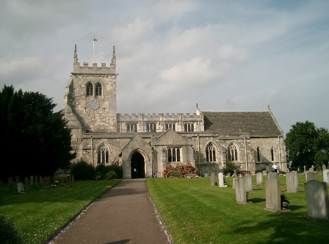
Apart from the layout of the historic town the medieval period is represented by the continued use of Athelstan's palace (up to the 14th century) and the Church of All Saints. An attractive church of several phases, All Saints replaced an earlier Saxon structure. Most notable is the 13th century chancel, which is a good example of the Early English style of ecclesiastical architecture.
Documentary sources show that All Saints was also a medieval hospital or hermitage dedicated to St Mary, reportedly this was situated close and south-east to the present church.
Huddleston Quarries to the west of the town were worked from the 14th century onwards to provide stone for York Minster. The Bishop's Dyke was constructed between the quarry and the Ouse at Cawood to carry the stone to York.
During the Scottish wars of the early 14th century the town was raised by the invading Scottish army. In 1321 a council of northern barons met with the Archbishop of York at Sherburn to discuss resistance to the Scottish army and possibly a revolt against the then monarch Edward II.
On Palm Sunday 1461, the Battle of Towton was fought near to Sherburn, between the villages of Towton and Saxton. The battle was one of the bloodiest battles of the Wars of the Roses (there were 30,000 estimated deaths) and led to an important victory for the House of York.
The 15th century Steeton Hall Gateway is a listed ancient monument situated approximately 2kms west of the village of South Milford and is one of four similar buildings that formerly identified the corners of the estate.
Post Medieval Period and Industrial Period (16th to mid 20th century)
The centuries proceeding the Middle Ages appear to be one of continuance, where Sherburn remained as a small market town within an agricultural landscape. Though growth did occur with a doubling of the population in the 19th century, Sherburn never went through the industrial expansion of neighbouring West and South Yorkshire towns.
The industrial base of the town remained largely rooted in agriculture. Throughout the period flax and teasel was cultivated for the linen industry centred on the West Yorkshire mill towns and it is probable that some production of linen occurred within the town from the 16th to mid 18th centuries. A 19th century trade directory states that the town is famous for its orchards, most notably a variety of Plum called the 'winesour'.
The vast majority of historic buildings surviving in the town date from this period and comprise farmsteads, detached and terraced houses and public buildings such as chapels and public houses. Typically for the area, limestone is the predominant chief building material with both pantile and slate used for roofing. The most notable building from the period is the village centre or former grammar school. It was built in 1619 as a school and hospital for both orphans and day pupils by the will of Robert Hungate.
During the English Civil War (1642 - 1646) Sherburn was the scene of a minor yet important battle on the 15th October 1645. The commander of Royalist Troops north of the Trent, Lord Digby, stopped at Sherburn to refresh his troops whilst marching to York. They were attacked by a parliamentary force and a skirmish ensued. The result was an unnecessary and embarrassing rout of the royalist troops that split the force in two. 150 Royalist horse were killed, including Richard Hutton, the High Sherriff of York, and a baggage train containing official documents was seized by parliamentary troops.
Modern period (20th century to 2003)
The 20th century saw one of the greatest social changes in the history of Sherburn, i.e. a gradual shift from an agricultural market town to a residential settlement, resembling a large village.
The development of the Gascoigne Wood Coal Mine and the Sherburn Industrial Estate & Business Park, still means that it is possible for a sizeable proportion of the population to live and work within the parish. However, the general shift of everyday working life moved away from the centre of the town. This factor and the large suburban expansion of the settlement, have fundamentally changed Sherburn's overall character within a short space of time.
Sherburn in Britain
Britain is such a small and densely populated country that every settlement will have a readily definable history. Sherburn in Elmet is no exception to this rule. On balance it is the early history of Sherburn that is most engaging; its place within the kingdom of Elmet and its connection to Athlestan and the Archbishops of York. Also its role within the major civil wars of the last thousand years can not be ignored. It is worth considering the extent of archaeological information, especially with regard to the Roman period and its is possible that this will become increasingly important over the next few years due to the expansion of housing within the area.
Such events have not left lasting and prominent physical marks on Sherburn. Athlestan's Palace is now a protected set of field remains that are difficult to interpret with the untrained eye, the kingdom of Elmet has passed leaving just a name. Consequently we are looking at a past that is largely encountered in the imagination rather than through physical monuments.
However, Sherburn is not without the physical remains of the past. Its basic layout is easily read as being from the Saxon and Medieval periods. The majority of its historic buildings relate its 18th and 19th century agricultural past. Sherburn does suffer in comparison with some other settlements, such as Tadcaster, in that most of its historic building stock has undergone some degree of modern alteration (window and doors replacement, cladding etc) and is interspersed with modern development that does not closely follow local traditions. The result of this is the low level of listed buildings for such a size of settlement and the absence of a conservation area. Whilst this is unfortunate it does not mean that such buildings are not valued by residents or seen as part of the intrinsic character of Sherburn.
Source.
A bit more on the civil war battle at Sherburn in Elmet.
No comments:
Post a Comment